Explore Rubirizi’s Physical Features
Discover the Unique African Shape Map
& Physical Features of Rubirizi
Nestled in the heart of Uganda’s Western Region, Rubirizi District is a spectacular tapestry of crater lakes, ancient forests, and dramatic rift valley landscapes — where nature, wildlife, and culturconverge in one of East Africa’s most biodivedes
📍 Western Uganda • East African Rift Valley • Queen Elizabeth National Park
Rubirizi on the Map: Uganda's Strategic Location in the Heart of Africa
To truly appreciate Rubirizi District, we must first understand its place within the iconic shape of Africa and Uganda’s strategic position on the continent. Uganda sits in the heart of East Africa, bordered by Kenya to the east, Tanzania to the south, Rwanda to the southwest, the Democratic Republic of Congo (DRC) to the west, and South Sudan to the north.
Rubirizi District is located in Uganda’s Western Region, positioned just south of the Equator along the Western Arm of the Great East African Rift Valley. This dramatic geological feature — one of Earth’s most spectacular natural formations — runs the entire length of East Africa, from Ethiopia to Mozambique, creating a chain of lakes, volcanoes, and valleys that define the region’s landscape.
Geographic Coordinates & Position
Precise Location:
- Latitude: 0°16’S (just south of the Equator)
- Longitude: 30°06’E
- Elevation: Ranges from 900m to 1,860m above sea level
- Average Town Elevation: 1,764 metres (5,787 feet)
Distance from Major Cities:
- Kampala: 364 km (226 miles) southwest
- Mbarara: 97 km (60 miles) northwest
- Kasese: Approximately 100 km north
Bordering Regions
Rubirizi District is strategically positioned at a geographical crossroads, sharing borders with:
- North: Kasese District
- Northeast: Kamwenge and Ibanda Districts
- East: Buhweju District
- Southeast: Bushenyi District
- South: Bushenyi District
- Southwest: Rukungiri District
- West: Democratic Republic of Congo (across Lake Edward)
This international border position along Lake Edward makes Rubirizi a critical gateway between Uganda and the DRC, with significant implications for cross-border trade, tourism, and ecological conservation.
The Remarkable Physical Features of Rubirizi District
Rubirizi District’s physical landscape is a masterpiece of geological forces, shaped over millions of years by volcanic activity, tectonic movements, and erosion. The result is a stunning mosaic of natural features that make this district one of Uganda’s most geographically diverse regions. Let’s explore the major physical features that define Rubirizi:
1. Water Bodies: A District of Lakes and Channels
Water is the lifeblood of Rubirizi, and the district is blessed with an extraordinary network of lakes, channels, and wetlands covering approximately 370 square kilometres (20% of the district’s total area). This abundance of freshwater supports fishing communities, irrigates agricultural lands, and sustains some of East Africa’s richest wildlife populations.
Lake Edward
Lake Edward forms Rubirizi’s western boundary, creating a natural international border with the Democratic Republic of Congo. This massive freshwater lake is the smallest of the African Great Lakes but remains one of the most important, supporting thriving fishing industries on both sides of the border. The lake’s shallow waters are home to abundant fish populations, including tilapia and Nile perch, making it a critical food source and economic lifeline for lakeside communities.
Lake George
Located in the northern part of the district, Lake George is a shallow alkaline lake known for its high productivity and dense fish populations. The lake’s waters are remarkably rich in nutrients, supporting massive populations of haplochromine cichlids and other fish species. Lake George is connected to Lake Edward via the Kazinga Channel, creating a dynamic aquatic ecosystem.
Kazinga Channel
The Kazinga Channel is a 32-kilometre-long natural waterway connecting Lakes Edward and George, running through the heart of Queen Elizabeth National Park. This channel is one of Uganda’s most spectacular wildlife viewing sites, with its banks teeming with hippos, crocodiles, elephants, buffalo, and countless waterbirds. Boat safaris along the Kazinga Channel offer visitors unparalleled opportunities to observe wildlife at close range in their natural habitat.
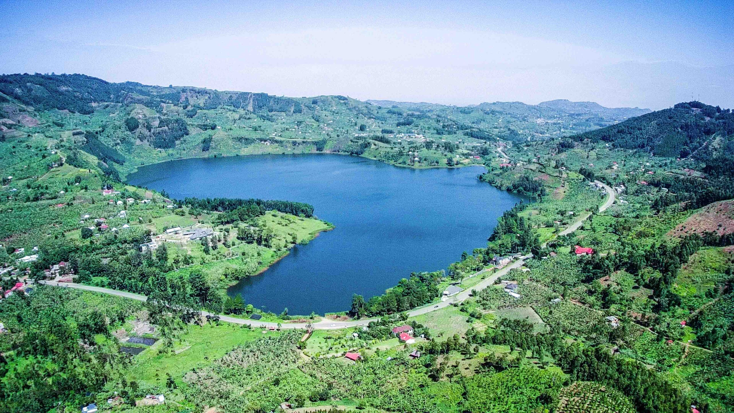
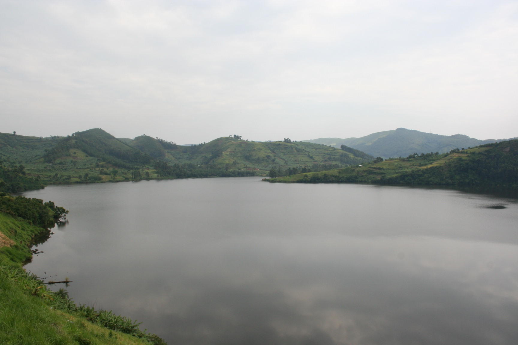
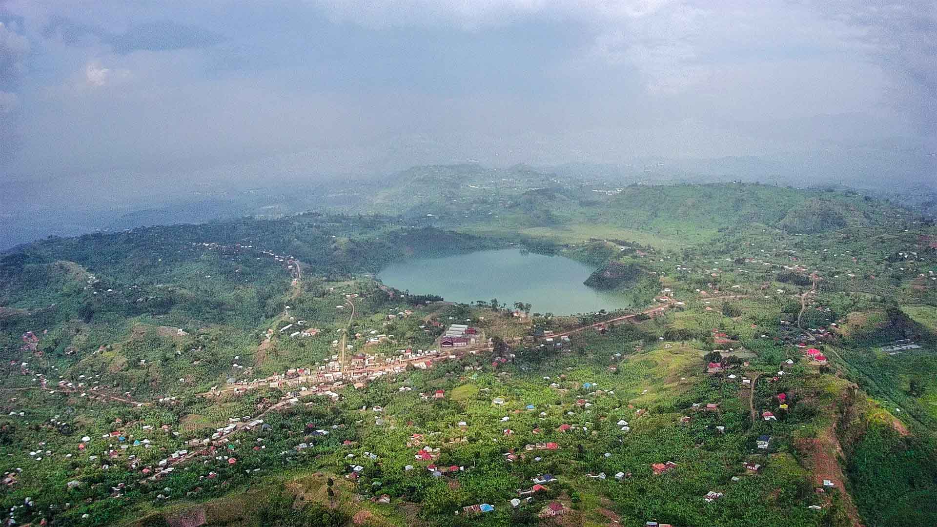
32 Crater Lakes
Perhaps Rubirizi’s most visually stunning water features are its 32 crater lakes — remnants of ancient volcanic activity scattered across the district’s undulating landscape. These circular, emerald-green lakes sit nestled in volcanic craters, surrounded by steep walls and lush vegetation. Each crater lake has its own unique character — some are deep and mysterious, others shallow and accessible. The crater lakes create breathtaking panoramic views and are popular destinations for hiking, birdwatching, and photography.
2. Ancient Tropical Forests: Uganda's Ecological Treasures
Rubirizi District is home to three of Uganda’s most important tropical rainforests, collectively covering approximately 784 square kilometres — nearly half of the district’s total land area. These ancient forests are biodiversity hotspots, sheltering rare primates, birds, butterflies, and plant species found nowhere else on Earth.
Kalinzu Forest
Kalinzu Forest Reserve is a medium-altitude tropical rainforest renowned for its population of habituated chimpanzees. The forest is one of Uganda’s premier chimpanzee tracking destinations, offering visitors the thrilling experience of observing wild chimpanzees in their natural habitat. Beyond primates, Kalinzu hosts over 378 bird species, including the rare African grey parrot, making it a paradise for birdwatchers. The forest’s dense canopy, towering mahogany trees, and network of nature trails create an immersive jungle experience.
Maramagambo Forest
Maramagambo Forest, located within Queen Elizabeth National Park, is one of Uganda’s largest surviving natural forests. The forest is famous for its bat caves, including the Nyanzibiri Cave and Python Cave, where visitors can observe thousands of bats hanging from cave ceilings and occasionally spot pythons waiting to ambush them. The forest also shelters forest elephants, leopards, chimpanzees, and numerous monkey species. Walking safaris through Maramagambo’s trails offer encounters with ancient trees, medicinal plants, and a symphony of forest sounds.
Kasyoha-Kitomi Forest Reserve
The Kasyoha-Kitomi Central Forest Reserve is a vast tropical forest shared between Rubirizi and neighboring districts. This forest is critically important for biodiversity conservation, serving as a corridor connecting Queen Elizabeth National Park with other protected areas. The forest supports populations of chimpanzees, red colobus monkeys, L’Hoest’s monkeys, and blue monkeys, along with forest elephants and bushbucks. Its dense vegetation and pristine streams make it an essential water catchment area for the region.
3. Queen Elizabeth National Park: Wildlife Haven
Approximately 50% of Rubirizi District’s geographical area falls within the boundaries of Queen Elizabeth National Park — Uganda’s most visited safari destination and one of Africa’s most biodiverse protected areas. The park sections within Rubirizi include the southern sectors, characterized by:
- Ishasha Sector: Famous for its tree-climbing lions, one of only two populations in Africa that exhibit this unusual behavior
- Maramagambo Forest Section: Dense tropical rainforest with chimpanzees, forest elephants, and bat caves
- Katunguru Sector: Gateway area with fishing villages and wildlife corridors
- Kyambura Gorge: A dramatic valley gorge offering spectacular aerial views and chimpanzee tracking
The park supports over 95 mammal species (including elephants, leopards, lions, Uganda kob, and warthogs) and an astonishing 600+ bird species, making it one of the premier safari destinations in East Africa.
4. Topography: Dramatic Elevation Changes
Rubirizi’s topography is characterized by dramatic elevation changes, creating a landscape of rolling hills, steep escarpments, deep valleys, and volcanic craters. The district’s altitude ranges from 900 metres above sea level at the lowest points near Lake Edward to 1,860 metres in the southeastern highlands around Rutoto, Ryeru, and Katanda sub-counties.
This variation in elevation creates multiple ecological zones:
Highland Areas (1,555m - 1,860m)
The southeastern highlands feature:
- Cooler temperatures (12.5°C – 20°C)
- Heavy rainfall (1,500-2,000mm annually)
- Dense montane forest vegetation
- Steep slopes prone to erosion and landslides during rainy seasons
- Rich agricultural lands ideal for bananas, tea, and coffee
Lowland Areas (900m - 1,200m)
The lowlands near lakes and the rift valley floor feature:
- Warmer temperatures (20°C – 30°C)
- Savannah woodland and grassland vegetation
- Semi-arid conditions in some northern areas
- Open plains suitable for livestock grazing
- Wildlife migration corridors
This undulating, hilly terrain creates spectacular scenic views, with panoramic vistas of crater lakes, forests, and the vast plains of Queen Elizabeth National Park stretching toward the horizon. However, the steep slopes also present challenges, including soil erosion, landslides during heavy rains, and difficult road access to some remote communities.
5. Climate & Vegetation: A Tropical Paradise
Rubirizi enjoys a tropical climate moderated by its elevation and proximity to the Equator. The district receives two rainfall peaks annually, with total precipitation ranging from 1,500mm to 2,000mm per year. Mean annual temperatures range from a cool 12.5°C in the highlands to a warm 30°C in the lowlands.
This favorable climate supports diverse vegetation zones:
Tropical Rainforest
Kalinzu, Maramagambo, and Kasyoha-Kitomi forests in the central district — dense canopy, high biodiversity
Savannah Woodlands
Open grasslands mixed with acacia trees in northern areas — ideal wildlife habitat
Semi-Arid Vegetation
Drought-resistant shrubs and grasses in parts of the northern lowlands
Wetland Vegetation
Papyrus swamps, reeds, and water-loving plants along lake shores and riverbanks
The district’s loamy, fertile soils with varying proportions of sand and clay support intensive agriculture, making Rubirizi one of Uganda’s important food-producing regions. The combination of favorable climate, fertile soils, and adequate rainfall enables year-round cultivation of bananas, coffee, tea, cassava, maize, beans, and vegetables.
6. Mineral Resources: The Rift Valley's Hidden Treasures
Rubirizi’s position on the edge of the East African Rift Valley has blessed the district with significant mineral deposits, particularly pozzolana (volcanic limestone). Pozzolana is a valuable volcanic rock used in cement production and construction materials. The presence of substantial pozzolana deposits presents economic opportunities for the district, though extraction must be carefully managed to balance economic development with environmental conservation and tourism interests.
Administrative Structure & Demographics
Rubirizi District was carved out of Bushenyi District in July 2010, making it one of Uganda’s newer administrative districts. Prior to independence, the area was known as Bunyaruguru County.
Administrative Units
2 Counties:
- Bunyaruguru County
- Katerera County
9 Sub-Counties:
- Rutoto
- Ryeru
- Magambo
- Kichwamba
- Katunguru
- Kirugu
- Katerera
- Katanda
- Kyabakara
2 Town Councils:
- Rubirizi Town Council
- Katerera Town Council
Lower Administrative Units:
53 Parishes | 294 Villages
Population & Demographics
Population Growth:
- 1991 Census: ~75,400
- 2002 Census: ~101,800
- 2014 Census: 129,149
- 2020 Projection: 144,100
Ethnic Composition:
Rubirizi is home to diverse ethnic groups including:
- Banyaruguru (indigenous/majority)
- Banyankole
- Bakiga
- Baganda
- Batoro
- Bakonzo
Economic Activities:
- 79% depend on subsistence farming
- 15% rely on employment/enterprise income
- Fishing, tourism, and trade also significant
Tourism & Economic Potential
Rubirizi District’s remarkable physical features position it as a premier tourism destination within Uganda’s safari circuit. The district hosts over 20 medium-star visitor facilities, including lodges, tented camps, and guesthouses catering to tourists visiting Queen Elizabeth National Park and the surrounding attractions.
Wildlife Safaris
Game drives, boat safaris on Kazinga Channel, tree-climbing lions in Ishasha
Primate Tracking
Chimpanzee trekking in Kalinzu and Kyambura, forest monkey encounters
Scenic Tourism
Crater lakes, panoramic viewpoints, Kyambura Gorge aerial views
Cultural Tourism
Maasai cultural visits, traditional homesteads, fishing villages
Beyond tourism, the district’s economic potential includes:
- Commercial Fishing: Lakes Edward and George and the Kazinga Channel provide sustainable fishing opportunities
- Agriculture: Coffee, tea, bananas, and food crops thrive in the fertile highland areas
- Limestone/Pozzolana Mining: Volcanic rock deposits suitable for cement production
- Beekeeping: The extensive forest cover supports honey production
- Eco-Tourism Services: Guiding, hospitality, transport, and handicrafts
Environmental Challenges & Conservation
While Rubirizi’s physical features are its greatest assets, they also present environmental challenges that require careful management:
Soil Erosion & Landslides: The steep hillsides, particularly in Rutoto, Kirugu, Kichwamba, and Ryeru sub-counties, experience severe soil erosion during heavy rains. Landslides can wash away banana plantations, destroy roads, and displace communities.
Human-Wildlife Conflict: As farmlands expand into wildlife corridors between Queen Elizabeth National Park and forest reserves, conflicts with elephants, buffalo, and primates have increased.
Deforestation Pressure: Growing population and demand for agricultural land put pressure on forest reserves, threatening biodiversity and watershed protection.
Overfishing Concerns: Unsustainable fishing practices on Lakes Edward and George threaten fish stocks and future livelihoods.
Conservation efforts led by Uganda Wildlife Authority, National Forestry Authority, and local communities are working to balance development needs with environmental protection through sustainable land use planning, reforestation programs, and community-based conservation initiatives.
Rubirizi: Where Uganda's Natural Wonders Converge
From the emerald crater lakes dotting the highlands to the vast expanse of Lake Edward stretching toward the DRC, from the ancient forests echoing with chimpanzee calls to the savannah plains where lions roam — Rubirizi District encapsulates the extraordinary diversity of Uganda’s Western Rift Valley landscape. This is where geography, geology, ecology, and culture intertwine to create one of East Africa’s most captivating destinations.
Plan your visit to Rubirizi District and discover why this hidden gem deserves its place on Uganda’s safari map.


Leave A Comment